

Program Overview
MCC’s $307 million Benin Compact (2006-2011) funded the $33.7 million Access to Land Project (ALP), which aimed to secure land tenure, improve land-based investments, and decrease land disputes. The project’s rural activities worked across 40 of Benin’s 77 communes and 294 villages to demarcate land parcel boundaries, produce village landholding plans (plan foncier rural, PFRs), establish and strengthen village- and commune-level land institutions, and increase public outreach to increase demand and issuance of land use certificates (certificate foncier rural, CFRs).
Evaluator Description
MCC commissioned World Bank’s Gender Innovation Lab to conduct independent interim and final impact evaluations of the Access to Land Project. Full report results and learning from interim and final findings: https://data.mcc.gov/evaluations/index.php/catalog/169.
Key Findings
Land Tenure Security
- Households in treatment villages were significantly more likely to report having parcels with clear boundaries at the end of the compact in 2011 as well as documented evidence of land rights at the time of final evaluation in 2015. However, these effects were not accompanied by a change in the levels of self-reported land conflicts.
Agricultural Investment
- In 2011, clear land boundaries led to an increase in long-term (i.e. tree- and perennial-planting) agricultural investments. Investment in perennials persisted in 2015.
- The gender gap in land fallowing, a key soil fertility investment, was closed in 2011, when women shifted production away from the now relatively more secure parcels within treatment villages towards land parcels outside treatment villages.
Agricultural Production
- Despite increased household investment, there were no effects on self-reported output or farm yields in 2011 or 2015.
Labor Market Participation
- In 2011, individuals in treatment villages were less likely to work as paid workers (in agricultural or non-agricultural positions) and more likely to be engaged in non-agriculture self-employment, but there was a short-run drop in off-farm wage work among female-headed households. These effects dissipated by 2015 with no impacts on off-farm labor market participation.
Evaluation Questions
The impact evaluation was designed to answer the following questions:- 1 What is the effect of the PFRs on perceived and de facto tenure security?
- 2 How does the PFR impact investment decisions and agricultural production?
- 3 What are the effects of the PFR on off-farm income-generating activities?
- 4 What are the gender-differentiated impacts?
Detailed Findings
Land Tenure Security
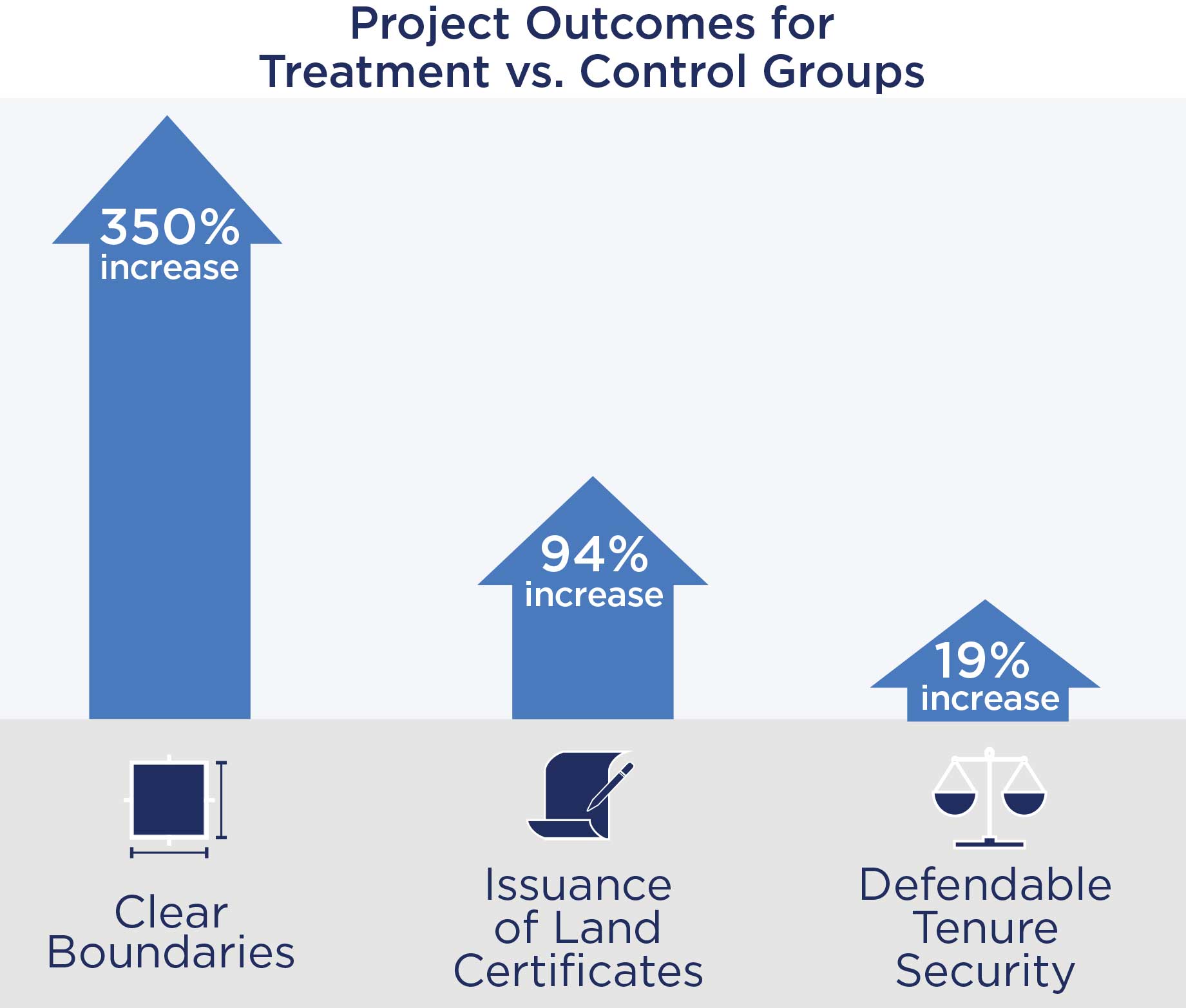
At the same time, in 2015, tenure security was also 3 pp more likely to be enforced through documentary evidence of land rights, representing a 23 percent increase from control villages of 13 percent. This effect was mostly driven by the issuance of land use certificates, which increased by 6 pp compared to controls of 0.4 percent. Despite increased clarity of parcel boundaries via land demarcation and land use certificates, there was no effect on perception of land tenure as measured by fear of loss of land nor any effect on incidence of conflicts in 2011 or 2015. There was no statistically significant difference between parcels managed by female- and male-headed households.
Agricultural Investment
In 2011, the evaluation found evidence that land demarcation activities prompted a change in farmers’ agricultural investments. Farmers shifted land cultivation activities toward long-term crop investment, including tree- and perennial-planting. Treated parcels were 2.4 pp more likely than control parcels to be used primarily for perennial crops, and were 1.7 pp more likely to have a newly-planted tree—almost 50 percent more than the control average of 4 percent. The evaluation found no evidence of continued investment in tree planting during the final evaluation in 2015. However, the proportion of parcels used primarily for perennial crops continued to increase, from 2.4 pp in 2011 to 3.2 pp in 2015—indicating that significantly more (nearly 50 percent more) treatment parcels were planting perennials compared to controls of 7.5 percent. In 2015, both female- and male-headed households continued their increased investment in perennial planting, though the increased investment in tree-planting was only observed in female-headed households.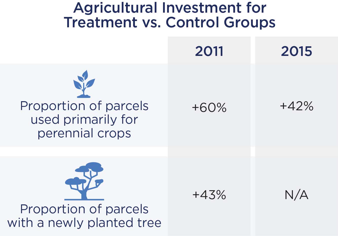
Agricultural Production

Worker maps land for demarcation.
Labor Market Participation
In 2011, following the land demarcation activities, there is evidence that household members in the treatment villages were less likely to work as paid workers (for off-farm and on-farm activities) and more likely to work in off-farm self-employment. In 2015, the evaluation found no evidence that being in treatment villages impacted household members’ decision to work as a paid worker or as self-employed in off-farm income-generating activities.MCC Learning
- Establishing land offices, design and installation of land information systems, provision of land certificates and legal changes takes time-often longer than the compact period and depends on government processing and approval.
- Random selection of beneficiaries in land is possible and provides key learning opportunities and results for expansion.
- Prior to titling, land demarcation in combination with a consultative land use planning process can change investment behavior.
- In certain contexts, provision of village level land rights in the statutory system or related buy in to common land use plans can initially lead to similar effects as provision of individual land rights.
Evaluation Methods
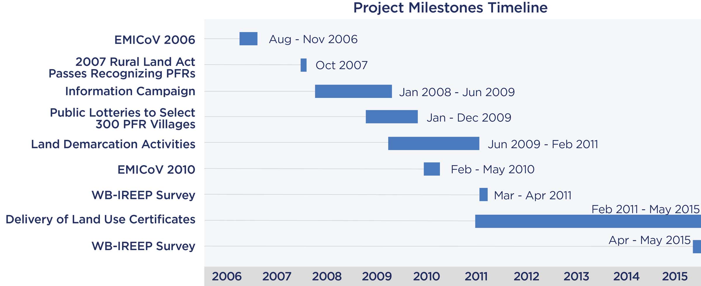
The evaluation employs a Randomized Control Trial (RCT) methodology, taking advantage of a unique feature of program rollout. All treatment villages were selected through district-level public lotteries that provided a public and transparent identification of treatment and control villages. The experimental sample covers 291 villages: 193 treated and 98 control. The geographic coverage of the survey spans the entire range of Benin’s agro-climatic zones, with data from nine of Benin’s twelve regions (départements).The evaluation used five sources of data to analyze the impact of the PFR in Benin:
- two rounds of primary household survey data on over 3,000 households (described in more detail below);
- secondary national household survey data via nationally representative EMICOV survey provided pre-intervention balance checks;
- land administrative data compiled from the PFR implementation units;
- commune-level survey data from 35 out of the 40 PFR communes; and
- KII and Focus Group data from two PFR communes.
The same sample of households was re-surveyed during the second and final data collection round in April/May 2015, which aimed at estimating the longer-term impacts of land demarcation in addition to the short-term effects of any land certification from the establishment and strengthening of village and commune land office and related public outreach. The panel dataset includes 3,276 households (6 percent attrition). It captured a five-year exposure period after demarcation with 97 percent of villages having completed PFRs and a 1-3 year exposure period after institutional strengthening and related issuance of land certificates. By the 2015 data collection, only 19 percent of the demarcated parcels had obtained a CFR with only six treated villages in the study sample having achieved full CFR delivery for demarcated parcels.
2019-002-2252