

Remote sensing - the science of using satellite or aerial imagery to monitor changes on the Earth’s surface - is enhancing the Millennium Challenge Corporation's (MCC) ability to monitor and evaluate its programs around the world, starting with Niger. MCC’s $437 million compact with Niger is focused on improving the sustainable productive use of natural resources for agricultural production and expanding trade and market access for agricultural products.
In developing the Niger Compact, MCC was faced with a set of data-related challenges to its approach to effectively monitor and evaluate the program. These challenges spanned from data quality and data availability, to the remoteness of participating villages and associated access and security challenges, as well as potentially high security premiums on data collection budgets. Traditionally, to understand the results of an agricultural intervention, MCC has used household surveys that require data collectors to travel from village to village and household to household, relying on producers’ memories and self-assessments of their cropping seasons, sale records, and profit potentials. This has proven to be particularly challenging in the Niger context. Finding alternative, efficient, secure, and cost-effective data collection methods is a must.
On perimeter plots growing onions (left) and cabbage (right).
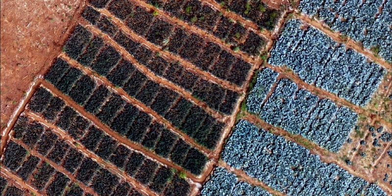
RTI International (c/o Jamie Cajka)
Looking for ways to mitigate the data challenges presented in the Niger Compact, MCC teamed up with NASA. NASA first worked to conduct a proof of concept for using satellite data to monitor the impacts of MCC agriculture investments. To that end, NASA tested the viability of remote sensing using Earth-observing satellites on MCC’s 2009 Burkina Faso Compact. In a recently published paper, NASA highlights the key findings on Estimating crop type and yield of small holder fields in Burkina Faso using multi-day Sentinel-2.
NASA needs higher-resolution imagery to train its satellite model to recognize unfamiliar crops and cropping patterns in Niger. To have more refined imagery, RTI International, which specializes in drone technology, joined the partnership to help develop satellite-based classification models. RTI uses drone imagery to identify crops, whose locations are then used to train satellite models. This, along with yield data, allows the models to predict and test the accuracy of crop identification and agricultural yields in other locations.
These innovative approaches and tools are a part of the data collection and analysis toolkit of MCC’s independent evaluator (Mathematica) for the Niger Irrigation and Market Access Project. NASA will provide MCC with an explicit roadmap for applying these models to MCC’s agricultural sector work and extend the methodology to implement in Niger and beyond. Ultimately, NASA will work to develop approaches and tools to use satellite data to continuously monitor and evaluate the impacts of irrigation infrastructure and land restoration investments on pastureland quality, crop density, and yield.
MCC’s ongoing collaboration with Mathematica, NASA, and RTI is set to deliver detailed results and learning about MCC’s Irrigation and Market Access Project in Niger. The integrated partnership builds on the strengths of each organization. For example, while Mathematica needs NASA’s high-quality satellite data to triangulate and strengthen its evaluation analysis, NASA counts on RTI to collect high-resolution drone images of crops to train the satellite model. Meanwhile, RTI relies on field-level observations, which come from household surveys and crop cuts conducted by Mathematica. Ultimately, a virtuous circle takes shape that will lead to a better understanding of agriculture and irrigation programs.
Specifically, for MCC, the partnership will answer questions such as:
- What’s happening in the field in the years when you don’t have on-the-ground data?
- What’s happening outside of the project area? Are there spillover effects and do we observe people adopting the benefits of a new crop type outside of the project area?
- How can other projects and organizations use these new tools and lessons?