


Program Overview
MCC’s $474 million Indonesia Compact (2013-2018) supported sustainable economic growth through the $228 million Green Prosperity (GP) Project. GP included the $38 million Participatory Land Use Planning (PLUP) Activity, which aimed to strengthen the capacity of local communities and district level institutions to manage their own land and resources and encourage investment. This was in support of GP’s objectives to increase productivity and reduce greenhouse gas emissions. As a way to decrease land conflict and improve land use planning and management, PLUP conducted boundary-setting and mapping at the village level and developed geospatial land databases at the district level.
Evaluator Description
MCC commissioned Social Impact to conduct an independent final performance evaluation of the PLUP Activity. Full report results and learning: https://mcc.icpsr.umich.edu/evaluations/index.php/catalog/180.
Key Findings
Challenges in Implementation
- Most Participatory Land Use Planning contracts successfully achieved outputs, but tight timelines and procurement delays threaten sustainability.
Participatory Village Mapping and Local Capability Building
- Village Boundary Setting was the most appreciated component for its high level of community engagement and alignment with technical requirements. Its high cost constrains replication, however.
- Villages mapped by PLUP comprise 20% of the definitively registered villages in Indonesia, despite being less than 5% of the total villages in the country.
- Policy changes during and post PLUP, including the introduction of a new online permitting system, diminished the use of PLUP’s district-level information management systems and all 35 systems were offline at endline.
Barriers to Investment and Promotion of Sustainable Development
- While PLUP generated interest and knowledge in geospatial data there is little evidence to suggest PLUP effected overall land-use allocation, administration, and planning.
Evaluation Questions
This final performance evaluation was designed to answer the following questions:- 1 What were the factors and challenges influencing PLUP implementation?
- 2 To what extent have PLUP outputs been sustained and short- and medium- outcomes realized and how did these vary across locations, gender, marginalized groups, implementers, and contract type?
- 3 What were the unintended results (positive or negative)?
Detailed Findings
These findings build upon the interim evaluation report results published in 2016.Challenges in Implementation
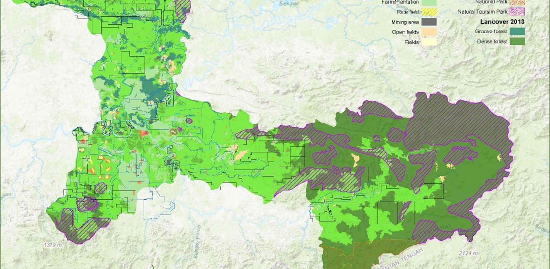
Map of Sintang District
Participatory Village Boundary Setting
PLUP mapped 363 villages in 17 districts across Indonesia. At the end of the Activity, 71% of PLUP villages were formally recognized by local government while the remainder either contained outstanding boundary disputes (42% of village leader respondents noted outstanding disputes at the time of the evaluation) or were still working their way through the government system for formal approval. Overall, the participatory Village Boundary Setting process was highly appreciated, though, when combined with the national government imposed technical requirements, was too costly for most sub-national governments to replicate in full. The evaluation found instances of district government and civil society organizations adapting the process to fit within budget constraints. In addition, 69% of government survey respondents noted that PLUP village maps had supported the development of their district spatial plans. However, at the village level, only 25% of village respondents noted having access to hard or soft copies of village maps, and the evaluation found no direct link with Village Boundary Setting and development planning at the village level.Land Office Capacity Building
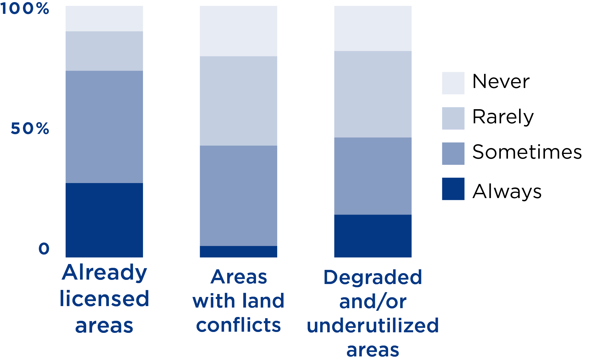
Geospatial data use when identifying certain areas
PLUP training was highly appreciated by government respondents for helping them understand and appreciate geospatial data administration. Several districts reported ongoing “geospatial clubs” initiated by contractors which featured discussions about tips and tricks for software use, and discussions about how data could be shared and used for planning in the district.
Barriers to Investment
While land office officials indicate that geospatial data use increased under PLUP, less than 30% of the ten GIS survey respondents noted always using spatial data to identify permit overlaps, and less than 20% always utilized data for identifying land conflicts or degraded and/or underutilized areas. All ten corporate respondents confirmed they do not rely on government data, PLUP or otherwise, for investment decisions. An analysis of investment trends in PLUP districts compared to non-PLUP districts within the same province shows no difference over the period from 2011-2021. 59% of government officials in a 2020 online survey suggested that PLUP had no impact on investments in their jurisdictions.The introduction of the Online Single Submission shortly after PLUP altered the permitting processes and the direct utilization of PLUP data. In addition, land-based investments are increasingly difficult to make in some of the PLUP districts, due to the restrictions on land-use. One district noted only 10% of land was available, and it was highly fragmented and unsuitable for large-scale investment. Where land exploitation is lower, there remain other barriers including poor infrastructure and systems to support investors, which was outside the scope of the PLUP design.
Promotion of Sustainable Development
PLUP was intended to provide foundational inputs to support Compact investments under the Green Prosperity Facility. However, procurement delays under the Project caused PLUP to run concurrently with GP investments. Therefore, although PLUP provided components for effective land use and planning, there is little evidence to suggest any impact on land-use allocation, administration, planning, or management or any alterations in any the use of high conservation value or degraded land. Similarly, no significant variations in results according geography, sex/marginalized groups, implementer, or contract type were observed.The focus of PLUP on government entities in land planning and use, rather than multi-stakeholder roles, limited the reach and relevance of PLUP. According to respondents, since PLUP worked largely on Village Boundary Setting and land-use planning at village and district levels, high conservation value land and degraded lands are usually outside the jurisdiction of the actors that it supported. Most high conservation value land and degraded lands are under the auspices of the Ministry of Environment and Forestry rather than local administrative jurisdictions. Therefore, subnational planning has limited bearing on land within the national forest estate.
MCC Learning
- MCC should be realistic with land investments that have dependencies on or with other non-land investments and ensure appropriately defined achievable project objectives informed by well-designed TOC.
- MCC should ensure sustainability planning for land and information system investments include securing multi-stakeholder buy-in and by de-risking mechanisms during project design.
- MCC should utilize comprehensive data quality review processes to determine data availability and accessibility before project implementation.
- When regulatory and technical reforms are needed, MCC should ensure dialogue and partnership with government agencies start very early in the project.
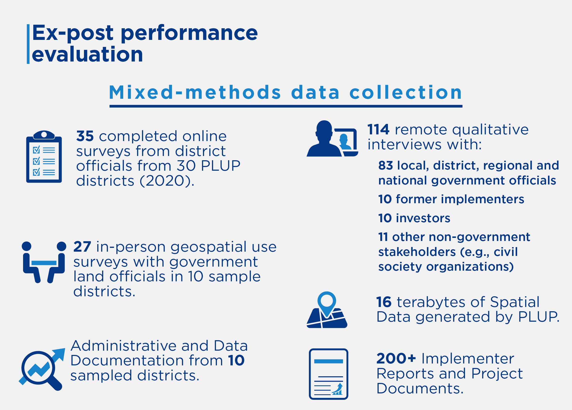
Evaluation Methods
2022-002-2727